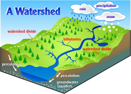
Drainage Basin :
land area where precipitation runs off into streams, rivers, lakes, and reservoirs. It is a land feature that can be identified by tracing a line along the highest elevations between two areas on a map, often a ridge. Large drainage basins, like the area that drains into the Mississippi River contain thousands of smaller drainage basins. Also called a "watershed."
All rivers receive a water supply and the area of land this comes from is known as a drainage basin. The boundaries of the basin are known as
the watershed and will usually be marked by areas of higher land.
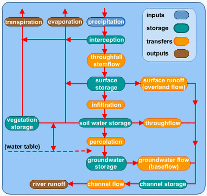
Drainage basins have many different characteristics that influence how quickly or slowly the main river within them responds to a period of intense rainfall, these are outlined in more detail in the section relating to storm hydrographs.
land area where precipitation runs off into streams, rivers, lakes, and reservoirs. It is a land feature that can be identified by tracing a line along the highest elevations between two areas on a map, often a ridge. Large drainage basins, like the area that drains into the Mississippi River contain thousands of smaller drainage basins. Also called a "watershed."
All rivers receive a water supply and the area of land this comes from is known as a drainage basin. The boundaries of the basin are known as
the watershed and will usually be marked by areas of higher land.
Drainage basins have many different characteristics that influence how quickly or slowly the main river within them responds to a period of intense rainfall, these are outlined in more detail in the section relating to storm hydrographs.
|
Watershed : the high land separating two river systems
This is, basically as said above, the boundaries of the drainage basin |
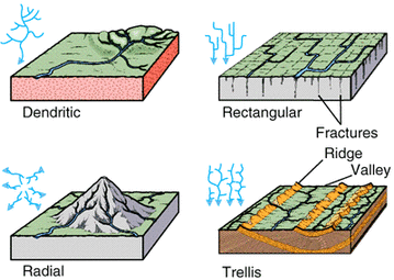
Drainage Patterns
Radical - Found in areas that are dominent by dome-shaped mountains or
volcanic cones, rivers radiate outwards from a central point.
Dendritic - Tree like pattern in which tributaries converge on the main river
channel. Usually developed in areas which have one rock type.
Trellis - Occurs on newly ip lifted land where the rivers and tributaries flow
down hill more or less parallel.
Rectangular - Found in areas that have under gone faulting. Streams flow paths
with less resistence therefore are concentrated inplaces where
exposed rock is weakest. Movement of the surface due to the steam.
As a result, the tricutary streams make sharp and enter the main
stream at high angles.
